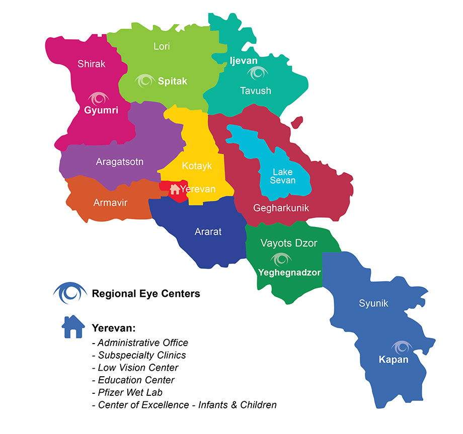
Armenian Geography
ARMENIA IS LOCATED IN THE SOUTHERN CAUCASUS. IT IS THE SMALLEST of the former Soviet Republics yet was the first to declare its independence after the fall of the Soviet Republic. Armenia’s area is 30,000 square kilometers, an area slightly larger than the state of Maryland. Contemporary Armenia is a fraction of the size of ancient Armenia. It is landlocked by Georgia on the north, Azerbaijan on the east, Iran on the south, and Turkey on the west. Much of Armenia is a rugged plateau of ridges, narrow valleys, extinct volcanoes, and small rivers and streams.
The two geographical features that stand out most about Armenia are the mountains and Lake Sevan. The republic contains numerous mountain lakes, the largest of which is Lake Sevan, which holds more than 90 percent of all standing water in Armenia. Although Armenia is landlocked, Lake Sevan takes up about 5% of the countries surface area and is at a very high elevation. The waters are crystal clean, often blue or turquoise, and always cold. Known as Armenia’s pearl, Lake Sevan serves as the main reservoir of Armenia’s irrigation system. Armenia’s main rivers include the Araks River, which flows into the Caspian Sea, and the Hrazdan, which flows from Lake Sevan into the Araks River in a series of majestic waterfalls. The Araks and Hrazdan Rivers provide almost all of Armenia’s electric power.
The average elevation is between 1,000 and 2,500m, with the lowest point being 500 meters. Armenia’s highest point is Mount Aragats, 13, 435 ft. The capital Yerevan is on the large, dry Ararat plain, which is about 1,500m above sea level. The Ararat Mountain Chain, also known as Sis and Masis, is located in what is now modern Turkey. It rises 7,000 feet and is visible from nearly every area of Armenia. Historically, Ararat has been the Armenian people’s most treasured landmark.
CLIMATE. Despite being latitudinally equivalent to more Mediterranean countries such as Spain, Italy and Greece Due to its high elevation and inland location, most of Armenia has a continental climate. The summers are very hot and the winters moderately cold, especially on the Ararat plain. However, Armenia also has innumerable microclimates. There are even palm trees in some parts of Karabakh. Rainfall varies greatly by location and elevation, with the greatest precipitation occurring on mountain slopes. Due to the mountainous terrain, beautiful waterfalls and ravishing rapids are frequent. Climate, soil, and vegetation vary greatly throughout Armenia resulting in Armenia containing twice as many soil types as European Russia. A very mountainous terrain includes temperate rain forests in the north and south, and arctic tundra like conditions on some of the highest peaks. If you venture into Karabakh, you will even see palm trees in some parts.
FLORA AND FAUNA. The wide variety of climates in Armenia accounts for the great variety of flora and fauna that can be seen at different times of the year throughout Armenia. Armenia contains twice as many soil types as European Russia and the climate, soil, and vegetation vary greatly throughout the country. Many of the world’s bulbs originate in the Armenian Highland, and there is a wide variety of wild bulbs in the country.
Armenian vegetation is typical of alpine, semi-desert, and steppe regions with the extreme southeastern and northeastern portions of the country contain forests of beech and oak. Large parts of the country are relatively undisturbed and still have wild grasses, flowers, trees and shrubs growing.
The animal life in Armenia includes wild boars, jackals, lynxes, and Syrian bears, mountain cats, deer among many others. Additionally, there is a huge variety of migratory birds stopping in Armenia, which is to them a land bridge from Europe and Asia. One of the most recognized Armenian birds is the stork.
NATURAL RESOURCES. Armenia’s natural resources are small deposits of gold, copper, molybdenum, zinc, and alumina. The land consists of 17 percent arable land, 3 percent permanent crops, 24 percent permanent pastures, 15 percent forests and woodland, and 41 percent other types of land.
CAPITAL AND CITIES. No state in the world has had so many capitals as Armenia. Prior to Yerevan, 11 cities assumed the role of capital city. These cities included Van, Armavir, Yervandasasht, Artashat, Tirgranakert, Vagarshapat, Dvin, Bagaran, Shirakavan, Kars, and Ani, Yerevan is located on the large, dry Ararat plain that is about 1,500m above sea level. Yerevan, 29 years older than Rome, is steeped in history with beautiful examples of art and architecture. Most of its buildings are covered with a rosy stone, “tuf,” that is quarried in Armenia, and the city is rich in monuments. The most popular of Armenia’s tourist destinations, Yerevan is beautiful any season of the year.
Armenia is highly urbanized and more than two-thirds of Armenians live in cities or towns. The largest city is its capital Yerevan. The next most populous city is Gyumri, formerly known as Leninankan, and is about one-tenth the size of Yerevan.
Yerevan, Armenia’s largest city is home to over a third of the country’s three and one-half million citizens. Once highly industrialized, with a flourishing manufacturing sector, Yerevan has suffered extreme economic hardships including a six-year war, blockades, natural disasters, and citizens exiting the country in shut down great numbers. As a result, industry has disappeared almost entirely.
The repercussions of Yerevan’s economic hardships are visible everywhere, but rarely so poignant as in the capital’s main square, surrounded by government buildings and the National Museum, where the singing fountains, whose waters once flowed with the sweet sounds of Armenian music, are now quiet.
TRAVEL. Armenia’s nearly 200 mineral springs attract tourists to local health resorts and spas. The water is said to have a natural healing effect and is supplied to the locals straight from its springs. Especially popular areas for patients seeking to treat minor ailments are the Arzni and Dzhermuk mineral springs.


